


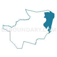
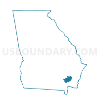
0253 - WAYNESVILLE Voting District, Brantley County, Georgia
About
Outline

Summary
| Unique Area Identifier | 560376 |
| Name | 0253 - WAYNESVILLE Voting District |
| County | Brantley County |
| State | Georgia |
| Area (square miles) | 52.21 |
| Land Area (square miles) | 52.15 |
| Water Area (square miles) | 0.06 |
| % of Land Area | 99.89 |
| % of Water Area | 0.11 |
| Latitude of the Internal Point | 31.29082830 |
| Longtitude of the Internal Point | -81.78648400 |
Maps

Graphs
Select a template below for downloading or customizing gragh for 0253 - WAYNESVILLE Voting District, Brantley County, Georgia


Neighbors
Neighoring Voting District (by Name) Neighboring Voting District on the Map
- 0252 - ATKINSON Voting District, Brantley County, GA
- 0254 - HORTENSE Voting District, Brantley County, GA
- 03901 - TARBORO Voting District, Camden County, GA
- 1271273 - STERLING ELEM Voting District, Glynn County, GA
- 1271303 - SATILLA MARSH Voting District, Glynn County, GA
- 1271373 - MARSHES OF GLYNN Voting District, Glynn County, GA
- 3053B - GARDI Voting District, Wayne County, GA
- 3053C - MT PLEASANT Voting District, Wayne County, GA
Top 10 Neighboring County Subdivision (by Population) Neighboring County Subdivision on the Map
- Jesup CCD, Wayne County, GA (22,247)
- Thalmann CCD, Glynn County, GA (9,225)
- Woodbine CCD, Camden County, GA (8,222)
- Waynesville CCD, Brantley County, GA (6,832)
Top 10 Neighboring Unified School District (by Population) Neighboring Unified School District on the Map
- Glynn County School District, GA (79,626)
- Camden County School District, GA (50,513)
- Wayne County School District, GA (30,099)
- Brantley County School District, GA (18,411)
Top 10 Neighboring State Legislative District Lower Chamber (by Population) Neighboring State Legislative District Lower Chamber on the Map
- State House District 167, GA (61,709)
- State House District 180, GA (54,520)
- State House District 178, GA (53,771)
Top 10 Neighboring State Legislative District Upper Chamber (by Population) Neighboring State Legislative District Upper Chamber on the Map
Top 10 Neighboring 111th Congressional District (by Population) Neighboring 111th Congressional District on the Map
Top 10 Neighboring Census Tract (by Population) Neighboring Census Tract on the Map
- Census Tract 10, Glynn County, GA (10,030)
- Census Tract 9601, Brantley County, GA (6,832)
- Census Tract 9706, Wayne County, GA (3,555)
- Census Tract 101, Camden County, GA (3,114)